Forestry & Land Resource
Consultants, Inc.
Consultants, Inc.
About US
Making Forest Soil Maps is our Craft
Making Forest Soil Maps Work is our Passion
Making Forest Soil Maps Work is our Passion
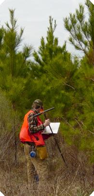
Forestry and Land Resource Consultants, Inc. is a group of soil
mappers or land classifiers or dirt digging foresters, whichever
you like, who make land classification maps for the forest
industry.
Our forest soils mapping experience is rooted in the
International Paper (GA, NC, SC, MS, LA, AR) soil mapping
project. We were all original mappers with that project in
1979.
Pete Kleto started contract mapping in '84 and Ed O’Brien
joined him in '85. We incorporated in '89 and Lewis Williams
joined shortly thereafter.
We've mapped land with the help of some talented colleagues
for Superior Pine Corporation (GA, AL) The Campbell Group
(TX, LA), Rice Land Lumber Company (LA),
Temple Inland (TX, LA, GA, & AL), Westervelt and Gulf States
(AL), Mead (AL & GA), Georgia-Pacific (AL, GA, FL), Plum
Creek (AL, GA, FL), Westvaco (SC, VA), Rayonier (GA, FL &
AL), USFS (GA & PR), Brunswick (GA) and Proctor & Gamble
Cellulose (Buckeye Cellulose) (FL & GA).